Please NOTE:
A part of our access to Cherry Tree Creek ran alongside PRIVATE LAND.
The law states that you must stay below the high water mark or seek the owners permission – Robert & Jenny Thompson. Please respect their property rights if you decide to undertake this trek. Get their details by telephoning the Jackagery Caravan park.
Mann Bindery National Park
53,346 ha nominated in 1988
Rugged wilderness known for its scenic river systems supporting large plant and animal populations.
Required topographic maps:
Mount Wellington 9338-I-S
Gundahl 9438-IV-S
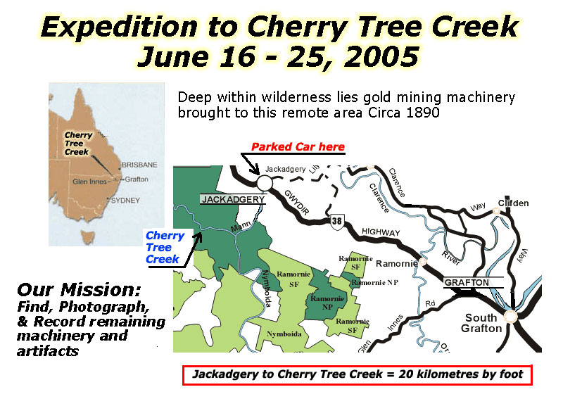
Jackadgery 9438-IV-NDirections:
Ballina to Grafton, 1.5 hrs
then take the ‘Gwydir Hwy’ to Jackadgery.
DESCRIPTION:
The New England Batholith uplifted and intruded into marine and terrestrial sediments at the end of the Permian age, ending a period of deposition. The Mann Bindery Wilderness lies on the north-eastern edge of the New England Tableland.
The Mann and Nymboida Rivers, which cut through the centre of the area, are wild and scenic rivers. The Mann has worn a valley through Ordovician sedimentary rocks, but as it approaches its junction with the Nymboida it cuts through the granite of the Gibraltar Range. The two rivers combine and flow over the rocky cascade called New Zealand Falls, to eventually join the Clarence River after Jackadery.
The diversity of soils, topography and climate combine to provide a range of habitats supporting an outstanding
array of plant communities.
Five distinct vegetation groups occur in the area.
These are:
The Granitic Plateau consisting of sedge swamps, heath, mallee, shrubby woodland, open forest and occasional rainforest.
The Sedimentary Plateau including warm temperate rainforest, subtropical rainforest and tall open forest of New England Blackbutt.
The Moist Escarpment in the steep drop off from the plateau to the Mann River valley and Cooraldooral Creek, consisting of tall open forest of Tallowwood, Blue Gum, and Brush Box.
The Dry Valley on the steep slopes on the southern side of the Mann River Valley and Cooraldooral Creek consisting of woodlands and open forests of Pink Bloodwood, Broad-leaved White Mahogany, Grey Gum, Grey Ironbark, Large fruited Blackbutt, Coastal Grey Box and Spotted Gum.
The Cunglebung Catchment distinguished by taller open forests containing Spotted Gum, Grey Gum, White Mahogany, Grey Ironbark and Brush Box. The area is in a biogeographic region that has a high biodiversity and concentration of threatened animal species, and is recognized as the second most important area in Australia for high priority species.
Twenty-eight species of animals listed as Threatened Fauna are recorded from the area. These include: the Hastings River Mouse, listed in imminent danger of extinction and one endangered fish, the Eastern Freshwater Cod.
LAND USE HISTORY:
Aboriginal
The area is in lands traditionally occupied by the Banbai Aboriginal people. The Bindery (Mann) area contains archaeological evidence of Aboriginal occupation for 4,000 years. Open campsites are well preserved in the Mann River terraces and sources of stone blades and axes are found on river gravels. Other stone artifacts occur on the higher ridgelines, indicating the presence of camps used en route to the tablelands.
Grazing
1838 Archibald Boyd of Stonehenge station follows Nymboida River to a point near Cunglebung in search of a route for a dray road in order to get wool to port on the Clarence River.
Pre 1990s Until gazette of Nymboida National Park extension in 1990, some of the river flats of the Nymboida River were used for grazing.
Forestry
1920’s & 1930’s First sawmills established on the Glen Innes to Grafton Road in 1920’s and by the late 1930’s three mills operate in the area. First electric saw mill established during 1930’s at Nymboida using electricity from the hydro-electric power station there and timber supplies from Dalmorton State Forest.
Mining
1870’s Gold was mined in small scale operations in the lower reaches of the Nymboida River and in the surrounding hills, but returns were usually poor. Subsequently, tin prospecting was undertaken.
OUTWARD JOURNEY
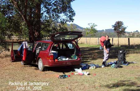
Awoke at 5AM and started final packing and preparations for closing our house. Everything went well and miraculously we got away by 8am. Beaut morning, crisp and crystal clear. We arrived at Grafton after a pleasant drive south on the Pacfic Highway where it follows the Richmond and Clarence Rivers, In Grafton, all the shops were gas heated and everyone was shivering. The grog shop lady summed it up. “It’s not a ‘real snap’, she said fast and sharp, ‘but it’s our first this winter and we’re feeling it,” said giving her shoulders a rub.
After Grafton, on the Gwyidir crossing river country. When it starts to climb towards he escarpment sits Jackagery on the Nymboida river. There’s a huge bridge there, quite high above the river, and just after lies a caravan park. Our road trip finished well with our meeting Owen, the new owner of the Jackadgery Caravan Park, which is where we normally leave our car. After explaining our mission, he was keen to assist, so in no time at all we were packing a mountain of gear into our packs. Soon they were dramatically over full. Jude rummaged thru hers, discarding clothes and the scant few luxuries. I re-packed mine, filling a few hollows, squashing, compressing it down till I could just get the lid straps closed, my sweater and camp loafers were tied to the outside.
I normally help Jude up with her sack, which I did, but for the first time I needed help to get mine on my back. Must have weighed 30 kilos. Ache in my left hip straight away. Bit of an alarm, hurt in abdominal hernia area too.
Departed from park at a snail’s pace balancing our load on a mostly easy going track. Ten minutes in, not halfway to the river, I decided to raise my lumber support belt, which you do by adjusting the harness back length. I shorten it 31cm. Felt so much better straight away.
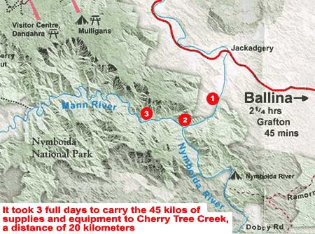
The first 8 Km’s follows the Mann River along privately owned river flats used for grazing. Over the years we have travelled this route many times and know the owners who have great concern for their livestock. In the past, some walkers have caused them trouble by frightening their stock, leaving gates open, and the kind of trouble that needs rescue. Common Law in NSW allows citizens to follow the course of rivers, which is what we do when on their land.
After these flats, the Gibralter Range rises from the river, making travel more difficult, more dangerous and slower.
From my notes for Day Two:
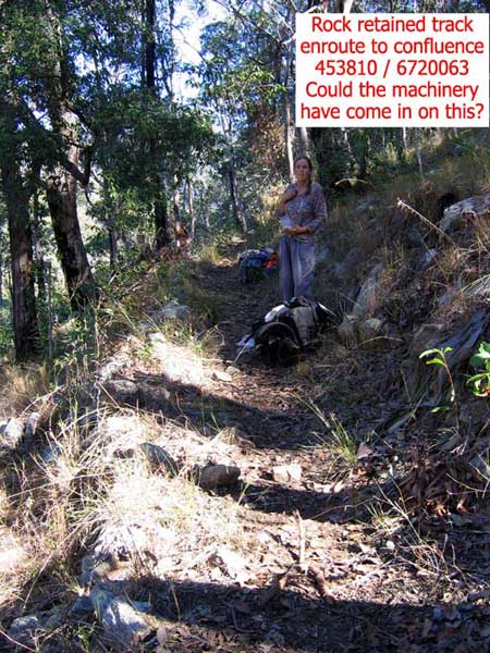
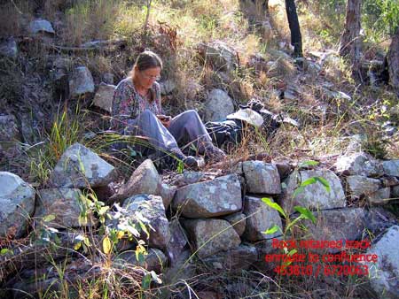
Tough day yesterday, heavy packs and a couple of poor choices made it hard going. Jude fell over twice, once hitting her head, or to be precise, her forehead stopped her fall. She broke skin. Worrisome. A lot of this section travels high on an ancient track supported by long rock walls. Built by who? And when?
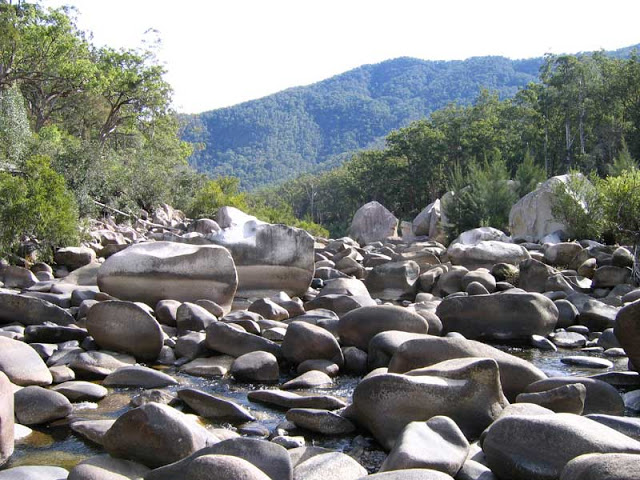
I got fed up with navigating over fallen trees, and my thirst had an effect, so I took us down thru miles of low bush, over rocks, searching for the water and an open path. We found the river, but by that time a new obstacle presented itself, the rapids and falls that lay a kilometre from the confluence.
If we had stayed high, on the old track, we would have continued up and down gullies to a series of grassy slopes leading down to the confluence. On our way out, we found this route blocked in many places by falling trees. But, at river level with heavy packs, it was another matter. We boulder hopped for the last kilometer. Beautiful, albeit dangerous with these loads.
Arrived at confluence campsite at 1500 hrs.
DAY THREE:
Campsite to near Cherry Tree Creek
A third hard day – again starting badly by poor my choice of routes. With the river at low levels, I decided to follow it in lieu of climbing up and down the ancient path. That was a mistake. An hour of boulder hopping gave us jelly knees, so we rejoined the track as soon as we were released from the rocky squeeze.
We then made fast passage from hard work along a narrow track carved into the hillside probably a century ago. Now, overgrown and blocked with fallen trees, it was often hard to follow, but their were times when we found long runs reinforced with rockwalls.
By 1300 hours we knew it would take all day to achieve the 5 kilometers to Cherry Tree Creek, so we had lunch on a pebble bank mid-river. Hot soup warmed our bodies while we discussed which side of the river looked the easier to trek. The southern side appeared a tad more open, so after packing up, we crossed to the south for a short easy walk that abruptly ended in another crossing.
At 1637 hrs, with little more than thirty minutes of daylight remaining, we arrived at a grassy flat just a half kilometre short of Cherry Tree Creek and when I dropped my sack, Jude yelped, ‘HOORAY!’
Quickly we made camp. The thin cloud that had started to drift in around mid-day had became a sheet of gray froth that blocked the moon from view. We made a lovely fire in the thick grass, then lay back in comfort enjoying some much deserved wine while a fine meal of cheese pasta, spiced up with salami for me, bubbled on the fire.
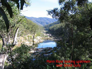
Looking up stream Mann River adjacent to Cherry Tree Creek
We use cookies to ensure that we give you the best experience on our website. If you continue to use this site we will assume that you are happy with this.OkPrivacy policy