Our Inheritance
Following in the wake of early explorers, in the shadow of decades on the sea and far afield in the natural world, Jack and Jude can see so much more. We imagine the cells, the nucleus of things. We see colours that evolve to seek the smallest of eyes. In the majesty of the quantum world, in the beauty of building blocks, in the tiniest of elements, we glimpse the privilege of being. And believe it is not our inheritance merely to abide in this beautiful world. It is our inheritance to understand it.
 As the secretary of the local Wildcare, after each winter Jack and Jude go around the various tracks our group tries to maintain, to tidy up what savage winter winds have done to the landscape. Because we have the liberty of choosing our time slot, these outings are fun, healthy exercise in Nature’s world. Even better, we gain satisfaction knowing our efforts allow many others an encounter with the exquisite natural world found around Macquarie Harbour.
Betsy’s Bay ~
First stop, ten nautical miles from Strahan lays Betsy’s Bay, a shark bite out the western hills that affords perfect protection in winds south to northwest. From there, an ancient track leads across the peninsula to the wild-west coast in a two-hour walk to total isolation at a fabulous smooth sand beach with several attractions. Just offshore, Sloop Rocks is near an aboriginal midden nestled near two fresh-water lakes.


We renewed a few red marking tapes and removed fallen branches from the track. Encouragingly, the track is getting used more often, helping to make it well defined. After a picnic lunch among the rocks with untrodden sea-washed sand at our feet, we ventured along the beach and over a dune to the first freshwater lake. Standing at water’s edge brought images of a night or two on its shores, swimming, fishing, in front of a fire where the first nation people celebrated life so long ago. That had me thinking maybe we’d feel their spirit in the quiet darkness of a starry night.
Back to Strahan after that, happily sailing under an ultra-blue sky, the wind aft, with mountains in view, to replenish supplies at the local IGA and touch base with mates before heading deeper into the never-never.
Soon a weather window of blustery northerlies came preceding a cold front, so we hoisted sail. Down here the weather changes often and we’ve become adept at picking the event to give us a thrill while making the miles, without pushing us and our veteran craft to uncomfortable limits.
Farm Cove ~
Rounding the ‘pin,’ Banyandah laid over on a reach into Farm Cove, to what we call the office with VHF communications, but no mobile phone connection, 17 NM south of Strahan. Under Mount Sorell’s pillars of might, we have fashioned many a word into lively passages of true life adventures, both good ones and the terrible. Farm Cove is a marvellous place to let your mind wander. But not this time.
Instead, we paddled over to the access track for Mount Sorell and the plateau that we try to keep clear and well-marked. Back in 2010, we trekked to the summit of Mount Sorell over three days, surrounded by enchanting vistas over the planet. But nowadays, we day walk to the top of the plateau for a picnic lunch with stunning views of the harbour and Southern Ocean.
Mount Sorell, at 1144 metres, is neither an Everest nor a Kilimanjaro. It’s just a peak, several in fact of similar height. Its chief difficulty is it has no points of easy access, therefore remains relatively untouched. Named after William Sorell, the third Lieutenant Governor of Tasmania, who founded the Macquarie Harbour Penal Settlement on Sarah Island in 1821.

Our Office
Kelly Basin ~
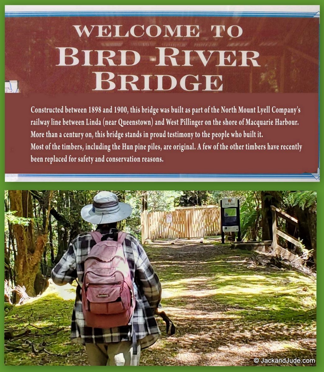
It’s hard to believe that 1,000 people once lived in the former mining town of East Pillinger, right next door in Kelly Basin. But in 1900, a thriving community serviced the railhead of the North Mount Lyell copper mine, which collapsed just a few years later, leaving behind its railbed that runs along the rainforest clad Bird River. Today, Parks maintains this lovely outing as one of Tasmania’s great short walks. Sadly, we were quite disappointed to find one of the walk’s highlights, the historic Bird River Bridge, blocked by an ugly treated pine picket fence at both ends. Now, a rather grand plastic grate walkway and powder-coated metal bridge gives access to the Queenstown road on the other side, which sparked thoughts on the proper use of public money. Who makes these decisions? Why not rebuild?
Sir John Falls
From Kelly Basin, with all sail flying, Banyandah reached to the Gordon River mouth then rounding the red pole, wing n’ wing to the first bend. After that, we worked the fickle blasts until the fun ended to motor easy past the ferry at Heritage Landing. Once around Horseshoe bend and out of sight of humanity, down went the hook in 8 m for a peaceful lunch surrounded by virgin forests. In the amazing tranquil setting, a lazy afternoon saw us saunter midstream to Snag Point, finding plenty of depth close around its outside bend while surprised to see so little of the sandbank. A few minutes later, our day’s journey ended around the next bend, with Marble Cliffs in sight. Anchoring in that short run offered plenty of protection from all winds, 8 m deep to a mud bottom.
A showery early start saw Jude and I arrive at Sir John Falls mid-morning, and seeing no other craft, we parked our lady alongside the main jetty taking note that Stormbreaker, the charter yacht that picks up the Franklin rafters, was not due until the following evening.
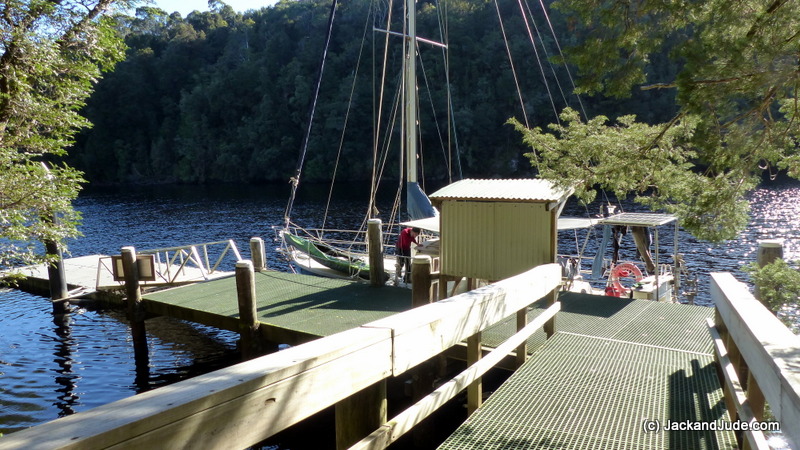
Our home away from Strahan – Sir John Falls Jetty 20 miles up Gordon River
Wishing the showers be gone during our midday repast, a lone kayaker paddled alongside for a chat. This cheerful fellow was returning from an outing to the first cave on the Franklin, and said he couldn’t get any further up the Gordon because too much water was coming down. That news washed away any thought of trying to paddle the Green Machine up to the Rocky Sprent like we did in 2012. That challenging feat captured in our film, Tasmania 2.
Instead, showers gone, we donned bush gear and boots, and grabbing our work gloves, took our tinny across Cataract Creek to inspect the Gould’s Post Track to Hamilton. Not looked at for two years, we were expecting a fair bit of tree fall.
The Gould’s Post Track to Hamilton was first cut in 1862, opening a way to the west for prospectors and miners, and their support. Piners and Hydro Tasmania used it later, taking supplies and pack horses further up the Gordon. For those who would like to know more about this important historic track that helped open up western Tasmania, here’s a synopsis.
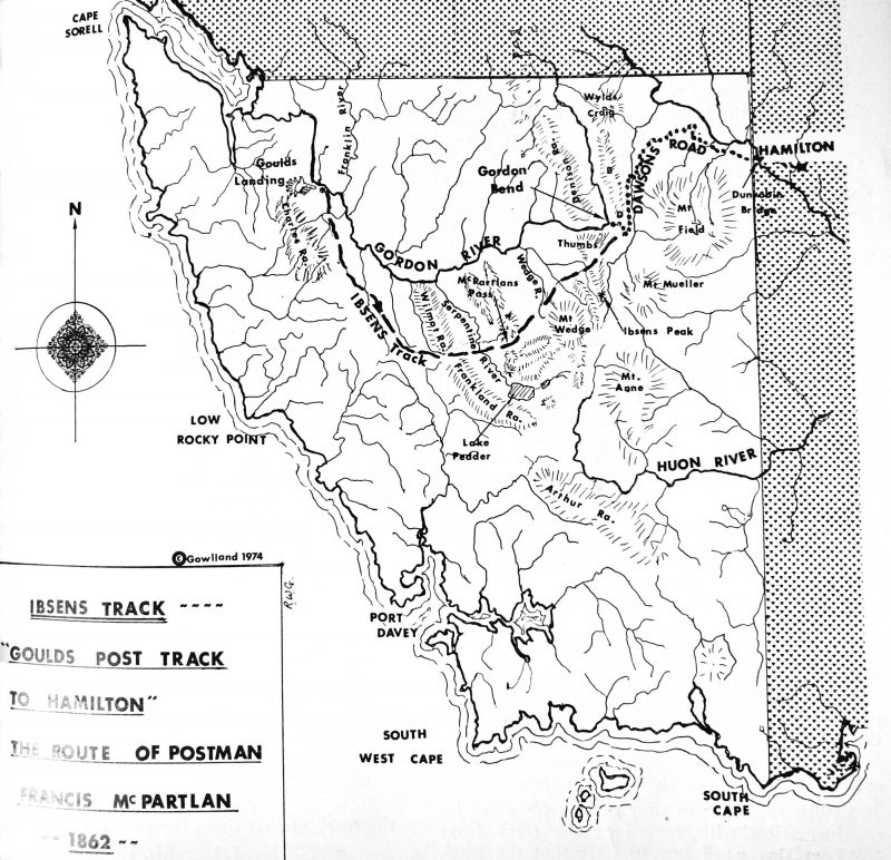
Historic Goulds Track
Immediately upon entering the former cargo storage area at Gould’s Landing, the beauty of pure Nature overwhelmed us. Down through the canopy filtered a multitude of soft beams of sunlight like ethereal foggy shafts streaming into a place of worship, blessing the collage of green. This matrix of peace brought us immeasurable pleasure, cleansing our spirit as we looked through the treetops towards the heavens to silently thank the creator for Nature’s perfection.
For the next four hours, Jude and I toiled, shifting fallen branches from the track we had brought back from oblivion. It felt good to re-establish a safe route through a kingdom where Huon Pine now dots the furrow of past labours, and young Celery Top Pine are growing taller, sprouting more and more of their unique celery like leaves. The old giant grandfather Huon Pine left by the piners to seed new young ones still stands by the side of the track. Its multiple trunks intertwined, making it too great for half a dozen outstretched arms to encircle. Very impressive, making it older than the birth of Christ.
Two hours into our cleaning, a voice startled us being so near in the forest silence. There a metre away stood our kayaking friend. He wanted to help. And his young muscles were very welcome.
If you want to help keep the track clear, please respect the living. Especially, note the tiny baby Huon and Celery Top Pines found along the shoulders of the track.
 Gould Landing location, either acess the track across from the jetty or the beach and opening 200 m upstream


