2010 OFFTRACK 8 day walk
42nd anniversary walk
 |
| Jason and Danny from Glen Innes Search and Rescue |
Celebrating an anniversary is often a candlelit dinner with a spray of flowers and good bottle of wine, but Jack and Jude like to be different. For us, it’s an opportunity to test our bonds, to challenge the other’s support, and be reassured that our union can conquer anything life might throw at us.
Many challenges, both physical and mental, can test unions, but the ones we actually enjoy most take us away from all human contact, to wrap ourselves tightly in pure Nature. Alone with Earth, there’s a calmness that draws us together and allows us to reminisce our achievements. But each year as we age, this trudge into the wilderness gets just that little bit harder.
Last anniversary, on a whim we walked one kilometre for each year of our marriage. Forty-one clicks, many on forest tracks, along mountain creeks, across a high meadow then a scramble up a cliff face to return. This forty-second year, we didn’t think we’d be so ambitious. Jude just had surgery on her hand to remove a fibrous growth, and to be frank, we weren’t in the greatest of shape having sat on our bums for months getting our first book ready to print. So we planned a series of short walks from a car camping base. (link to last year’s walk)
But our planned easy stretch snowballed into a full-on physical challenge when we opened the topographical map and saw our old route to an abandoned gold mine we’d discovered ten years earlier. Hmm, wondering what Cheery Tree Creek looks like today kept popping into our conversation as we drove into the mountains up the Gwidir Highway. We couldn’t help wondering whether the massive steel boiler taken to that remote location by bullock cart over a hundred years earlier was still at the head of the creek.
We don’t always make rock solid decisions. Sometimes we just go with the flow and see how things develop and that’s what we did right up until we’d driven into the Gibraltar Range National Park and slept that night in the campsite. Next morning, while sorting meals on the park table and packing our rucksacks, Jude asked, “How many days.” And I answered, “Well, we could go down Raspberry Creek for a couple of days then back here to repack for jaunt somewhere else.”
“But what if we do the whole route to Cherry Tree?” Jude persisted.
I shot her a sideways look, and then replied, “No less than a full week, but what about your hand. It’ll be tough going.”
“I could wrap it,” she sort of whispered, half in thought.
When my eyes widened in disbelief she pulled a crepe bandage from our medical kit and showed me how effectively she could protect the wound. Now wilderness can be easy going in open forest like near the mine site, or conversely it can be a devil in wetter areas where vines and thick undergrowth thrive. With this in mind I perused the map and identified a new, shorter route to the gold mine, one across a high altitude plateau to the escarpment directly above Cheery Tree Creek.
Trekking to Cheery Tree Creek
Realizing the plateau might be swampy, I also knew it would be open, fast, and easy, and would lead to a network of old logging roads, which, if still viable, would speed us to the escarpment. After that, we’d be in open forest.
When I outlined this new route to Jude, she became very excited and almost insisted we give it a go. So I relinquished. “Okay. Pack food for a week and an extra day just in case the going is tougher than we think.”
Well it didn’t take Jude long to make eight piles of daily rations, not a mean feat, while I sorted our base camp equipment and wrote a note to leave on the car windscreen.
View Anniversary Walk 2010 in a larger map
When packed, all up Jude carried about 15 kg on her back while my rucksack weighed near on 20 kg, the three litres of red wine, sweets and nuts making up the difference. Jude needed help up with her bag, and I barely got mine over my head, loading it like a scuba diver heaving on his tank.
What a glorious sunny morning it had become by the time we locked our car and set off down the track to the Murrumbooee Cascades, an easy walk filled with sweet forest aromas that kept the pain of carrying so much weight out our thoughts.
 |
| Murrumbooee Cascades |
An hour later, the track ended at Dandahra Creek just where it squeezes through a rock gorge and the roar of water thrilled us at first. But it turned to alarm when we realized we’d have to ford the waist deep rush of cold water that was so unlike the last time here, when it had been just a trickle. Upstream through scrub we found the best chance of success, and removing boots and trousers, we entered the water wearing only Crocs. Crikey, I had nearly made it across when one of my shoes got stuck between smoothly worn boulders. Too deep to reach down with my rucksack on my back, and too far from land to dump the sack, I had no choice but to rip my Croc free, tearing away the rear strap.
 |
| We saw dozens of Waratah |
When eventually across, an undulating land loosely vegetated with dwarf trees and thin undergrowth let us easily transit the first part of the high altitude swamp. And using our wilderness skills as well as verifying our position with a handheld Etrex GPS we fairly quickly traversed nearly seven kilometres through a colourful parade of wildflowers. One surprise was the gorgeous red waratahs that added extra zest. A stout, erect shrub they grows to 4 metres, with a red bowl like flower surrounded by dark green leathery leaves coarsely toothed, the Waratah has been the official floral emblem of New South Wales since 1962.
 |
| The Waratah, official floral emblem of New South Wales since 1962. |
 |
| A short cat nap after the heavy going |
Pleasantly exhausted after our first day’s walk, we set up camp in an open glen with a small watercourse just a few minutes away. Tent erected, an open fire with dinner bubbling at its side, a beaker of red wine eased the pain in our backs and shoulders.
We like to start a day in the wilderness rather slowly; we’ll lay in bed listening to the birds serenading the rising sun, then sip a brewed coffee while the sun warms up the day. Following a breakfast of cereal and milk we might look at the map and discuss our route while waiting for the morning dew to dry off the tent. Particularly slow that morning, we didn’t get away until around 11 AM.
That second day, midway across the high plateau that’s all above 1000 m, we were in heaven. It wasn’t near as wet underfoot as the full creeks indicated, and just ahead our map showed logging tracks from 30 years earlier when this area had been State Forest. Finding them would help us swiftly cover the remaining 13 km to the escarpment.
In high spirits we enjoyed lunch in a near perfect setting that had me boasting we’d discovered an easy fast route to Cheery Tree Creek while I entered a GPS waypoint to where I planned to intersect the first forest road. Alas, that was our last moment of elation.
Soon after we started walking again the undergrowth thickened. Gone went the open spaces as we entered an area of thick saplings standing close together like jail bars. Woven through them were several types of vines that dragged at our pants. They were horrid enough but then we encountered tendrils of thorny raspberry vine along with them. Growing shoulder height, those barbed devils tore skin off our arms, hooked into our faces, and virtually stopped our forward progress. God, how they sapped our strength and tested our patience.
 |
| Pushing through – 600 m took 4 hrs |
My going first made a tunnel for Jude to follow. That’s how it’s always been, but after an hour’s battle I was roaring in agony, telling Jude to push ahead and give me a break. Then the going got dishearteningly tougher, especially as every moment we were expecting a forest track to open ahead, but instead found more living hell waiting. Travelling one lousy kilometre took all that second afternoon, and when we didn’t find a forest road where the map indicated a road junction, we pushed open an area large enough for the tent and collapsed. That night it took more than a beaker of wine to ease our pain. We covered a total of 4 km that second day.
Next morning positive vibes had recharged our determination as we were sure we’d find an old forestry track that morning. Our legs had been mauled and with our arms a mass of red welts and embedded with thorns, every step was extra painful. But deciding to push on, I repeatedly established waypoints smack on the supposed forestry track. And as we hit them, sometimes something resembling an old track appeared. But they were so thick with saplings they were soon lost in a confusing mass, leaving us with the impression that the entire area had once been raked by machinery and the regrowth had come back thick with vines that might take a couple of hundred years before a normal forest becomes established.
 |
| Purple bell shaped flowers of Australian Mint Bush |
About lunchtime, we’d forged through just one more kilometre of living hell. When, in one step, miraculously I burst out onto a wide forestry track. Hallelujahs roared out my mouth as I beheld an easy track festooned with stunning purple bell shaped flowers covering rampant Australian Mint Bush. Having much to celebrate we sat in cooling shade drinking in birdsong while gorging on a simple lunch of cheese and crackers.
After that, we trudged along a boring track clocking up kilometre after kilometre, until after six of them we arrived at our point of departure for the escarpment. Dreading what might lie on the other side of the thick verge, we shrugged, gave each other encouraging kisses then plunged back into raw forest.
First requirement then was to find water. We’d passed none since leaving camp that morning, so we plotted a waypoint to a watercourse shown on the map, which we found relatively easily after hearing cascading water within minutes. Nothing is grander than pure mountain water. Its cool sweetness is so refreshing we guzzled a litre each before filling our water bottles. Late afternoon now and needing a campsite we trudged on while the undergrowth grew ominously thicker. Our world got darker from thickening vegetation as our clothes became drenched in sweat. Then as sometimes happens, the forest floor became open with leaf litter and I immediately chucked down my bag, calling out that’s enough. We’d tackle the escarpment tomorrow. Happy Anniversary Love.
 |
| Camp 3 – at about halfway. The peacefulness turned to rain, so stay in bed the next day |
Surrounded by large trees, our camp was pleasantly calm and quiet, the moist leaf mulch soft and fortunately not hiding any leaches, so we plopped straight onto the ground. Making camp that night was somewhat difficult; we still had to find firewood, and it took quite some time to light the damp wood. But not before the wine cask was dug out and passed between us.
It rained that night. Dawn, if you could call it that in such a dark hollow, was shrouded in mist and wet with drizzle. A perfect excuse to stay in bed. Man, my legs were a mess; stiff, swollen, scabbed and cramping unless kept straight out. I made a cuppa for my lady then we had brekkie in bed. The drizzle turned to honest rain, so we cuddled up to belatedly celebrate 42 years of marriage. That wiped out the morning and we didn’t emerge from the tent until past midday after declaring it an official rest day.
Next morning we were full of beans and hot to start. Packed up and away by 9 AM, we immediately encountered our old foe; thick, thorny raspberry bushes. Our map showed a measly 600 m to the drop-off and we had reckoned we’d be there within an hour and then down the 900 m escarpment in another three or four. There had been talk of lunch at the Mann River. But that 600 m got tougher and tougher. It tore open our wounds and inflamed our bruised shins. After four hours of painful hard work, we caught our first sight of downhill gradients and collapsed for a rest and lunch.
 |
| master chief of the forest |
Still confident of making the river by dark, we ate quickly then started down with vague distant views of the immense Mann River valley sometimes peaking through the thick foliage. Normally, navigation down a ridge is fairly straight forward. Stay to the highest ground and follow it down making sure not to loose footing. But this one wasn’t so straight forward. The vine and raspberry was still dense, forcing me to search ways around the thickest areas and that made finding the highest point all the more difficult.
Well, you know Murphy’s Law. “Anything that can go wrong, will go wrong.” An hour after lunch, when the gradients had gotten really quite steep, the forest opened up and sure enough, across a deep gully we saw a second ridge. My heart plummeted. I knew straightaway we should have been on it. Collapsing, I lit up the GPS and it confirmed I had wandered onto a really steep arm that was descending into a wet gully. Jude was adamant it would be daft to go back up, not through that thick crap, so we planned an escape route thinking we could still make the bottom before dark.
Gosh, that slope got dangerously steep. Big rocks popped up through the vegetation, forcing us to take each step even more cautiously. This was no place to break a hip as images of a helicopter trying to winch us out kept us methodically testing every footstep and checking our grip on the surrounding saplings.
About four, to the crash of thunder, dark clouds started to form over the valley with more than half the escarpment still to conquer. At five, a blinding flash in the heavens started a downpour. Already wet from exertion, the cold rain brought chills and flooded our vision. Desperately I examined anything vaguely flat fearing being stuck on the mountainside in rain and darkness. Then a miracle, if you can call it that. On a 45 degree hillside, earth had piled up behind a large Ironbark tree, just enough for our tent if its corners hung in empty space. Jude and I quickly held a loud confab in the pounding rain, and deciding we’d not make the bottom, I began erecting the tent, a death defying feat.
Slithering in, our wet bodies slid across the plastic floor till we hit the tree and except for the noise of rain on fabric, we suddenly felt a huge tension released. Into each others eyes we looked for reassurance. What the heck were we doing there? My God, we’re retirees. We should be safe in a house, playing with our grandkids, not perched on a mountainside with calamity about to strike. Jude smiled then let out a cackle that infected me, so with darkness falling we must have sounded slightly insane. Our anniversary! Together 42 years and instead of a candle lit dinner, there we were locked away in a makeshift jail hanging over a precipice. Rather sexy we thought.
Jeez my lady’s a magician. In the tent’s vestibule she whipped up a warming mug of soup followed shortly by a tasty noodle dish with lovely fresh veggies she’d carried in. Then to the tune of a raucous downpour we slipped into each others arms and recounted other horrible moments that had eventually come good. Neither of us remembers falling asleep.
The noisy laugh of a pair of kookaburras auditioning for Nature’s X Factor roused us just as the morning sun showed us hemmed in by thick vegetation.
“No breakfast or coffee, hey,” I mumbled to Jude. “I’ll just collapse the tent and we’ll get down to the valley floor instead.” Then I nudged her gently as she seemed more intent on turning over for another hour of kip. I wanted out of there. Besides, I had to pee.
Rising out the tent, where a slippery mud slope started right at our doorstep, in my haste, I fell straight on my face. Crap! Wet straight away and full of muck.
After dressing in cold wet garb, I rolled up our wet tent, packed my bag and then we were off. And, do you know, we felt grand. Earth was awakening. Honey eaters and warblers were trying to out sing one another as sticky mist steamed off the hills. Far below we caught glimpses of our destination; the winding ribbon that was the Mann River.
 |
| drying our garb became a ritual |
A couple hours of careful trekking, slipping and sliding down the hillside, and crossing creeks we reached the river flats. And straight away we came upon a wide area clear of vegetation, a perfect camp. Back up went the tent and quickly a fire was established to dry our wet clothes. After an easy lunch, now dressed in our warm, dirt stiff pants and denim shirts we set off to explore Cherry Tree Creek.
 |
| yet another cloudburst – Mann River Valley |
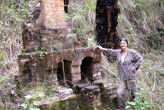
First established in the late 1800s when gold was discovered in granite rock along the Mann River, three mines soon developed. The gold was difficult to extract, requiring stampers and settling pans to extract small quantities. Nevertheless, financing was found and equipment was purchased from England, including a five metre long steel boiler that somehow was got into that isolated mining site by bullock cart. Because of the rough terrain, transport of supplies both inward and out was difficult, and although the miners demanded a road be put through from Jackadgery, government funds never eventuated forcing the mines to collapse in the 1920s.
 |
| walking bedraggled and wet through |
Today, Cherry Tree Creek lies within the Mann Bindery Wilderness Area administered by National Parks. The gold mines and equipment lie on the south side of the Mann River, and as we were on the north side we would have to cross the river. First sight of it sent our hearts into our mouths as it was raging in flood. Nevertheless, after reaching our normal crossing, I shucked off my pants and boots, donned my Crocs and proceeded into the rock strewn shallows. Ten metres in, I knew Jude wouldn’t be able to make the crossing and tried turning back, but instead overbalanced and fell flat on my back.
“#!*#!!” I sputtered trying to get out the rushing water as it tried to carry me downstream. Waterlogged and dripping, I emerged back on the bank.
“We’re going to have to swim if we want to visit the mine site.” I said as water drained off me like that from cooked spaghetti in a colander. Surprisingly, after a look up and downstream, she said, “Yeah! I’ll do that.”
Choosing a wider, slower section of river further upstream and leaving behind our boots, Judith packed her waterproof Olympus camera in a bag then entered the pool that was surprisingly deep. Then we set off breast stroking. Gosh, we must be getting on. That river took us downstream faster than we could get across. Both of us got washed into the rough turbulent rapids where Jude’s camera floated off in its plastic bag. Rushing up the far bank she had to make a dash along the dry river stones to retrieve it. After that little drama, wet and dripping, we trudged up the other bank, making squelchy sounds traversing the rocks.
Investigating the concentrator site at the head of the creek, we discovered it had been re-arranged by flood since our last visit three years earlier. A wall of small, smooth stones had been washed out the creek and had invaded the machinery site, knocking the big boiler off its feet and covering most of it. The Huntington mill was hidden, that area completely overgrown with lantana in flower.
 |
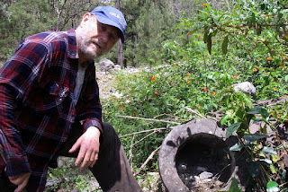 |
| the boiler in 2006 | the boiler now on its side and filled with rocks |
 |
| Smelter from late 1800s |
After documenting all this, we wandered up creek finding it relatively clear, and in fact, a joy to walk as there were little pools and trickling waterfalls. Nearly a kilometre up that creek, we came upon the old brick smelter built more than a hundred years ago and were delighted to see it much the same as our last visit. Of course, all this snooping about reignited old memories of discovering this place and our subsequent visits when trying to determine just how the old timers had got that huge steel boiler into such an isolated place. Therefore we were pretty satisfied with our efforts when it came time to re-enter the river and swim for our camp on the northern shore.
That night, we had another big fire. Easy to do down in eucalyptus forest, and dried our bush gear yet another time. Next morning, according to the note left on our car, we were due out that day. But there was no way we could cover the 15 km in one trudge. So we opted to have an easy morning before tackling the brutal jump to the major camp at the confluence between the Mann and Nymboida 5 km downstream. That might seem just a jaunt along a big river, but sections crossing various streams were challenging. Making it even harder, it clouded over, got nasty, and poured buckets on us, so we arrived at our last camp drenched yet again.
Jude was in agony by then. Her back and hip had had enough and her every step made her grimace. Unusual to see my lady down at the mouth. But to be truthful, I was a bag full of pain too. Maybe I’m more masochistic; I just endure the pain as part of the journey thinking if we want to achieve adventurous challenges then that’s the price at our age.
After an hour of hearing her complain, unusual for her, I gave her a blast. Yep ladies, you don’t want to married to me. No, cuddle this time. No sweet reassurances. I’d already given her those. Just a straight out lecture on how lucky we were to be able to do the things we do. Then I slapped her with the black knight. “Crikey, I’m at the front taking the brute of it. So, brighten up, I’m sick of hearing you moan.”
 |
| After the rain cleared – Mann & Nymboida Rivers |
Uagh! Not the most chivalrous. But it had the right effect. It’s easy to feel sorry for yourself when the going gets tough. And that just makes everything seem even worse. But with some effort, we can focus on the positives, and that has a magical effect on pain. Jude sat quiet for a few minutes. Then as I stood rigidly gazing back upstream at the candy floss mist clinging to the forested mountains, she slipped up behind me and put her arms round my tummy then began nuzzling my ear. “I’m so lucky,” she proclaimed as I turned in her arms to behold a full moon rising behind the superwoman I’ve loved for more than 42 years. Maybe the pain hadn’t evaporated, but she suddenly wore a smile and moved with ease.
 |
| Camp at the confluence – Mann & Nymboida Rivers |
What a last night. Our camp sat next to a lake created by two big rivers meeting where green mountains soar towards the heavens. Upon those waters the rising white lunar orb cast a long ladder of light direct to Jude and I cuddled next to our fire where we blabbed on and on like kids planning their next adventure. Just another big sleep and we’d wind up this trek that had bonded us even more closely together. To us, this is the way man and women are meant to live together. Facing challenges, tackling them together, supporting one another, and then taking pride in overcoming adversities. Maybe not every couple sail yachts round the world or trek wilderness, but everyday life is just as demanding and should be faced as a team. Two’s a Crew, it’s much stronger than one plus one, built on the strength of the other like a magnifying glass multiples the power of the sun.
The way out from that camp we knew well. An easy walk of 11 km along pastures and river flats saw us at the Jackadgery Bridge where a new adventure awaited.
 |
| The last 100 m – Mann River Bridge at Jackadgery |
A funny footnote to this story is that when we added up the distance we’d walked, it came out exactly 42 kilometres. Oh my god! We’d better start training for next year!
Links to our discovery walk 2005:
Discovery expedition to Cherry Tree Creek
Abandoned Gold Mining Equipment