
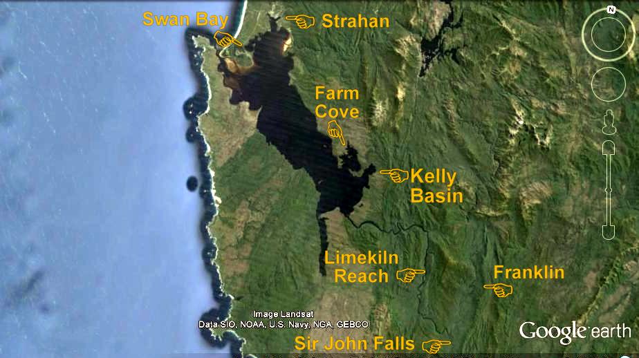
Continuing The Hunt ~ Early April 2015
For a week after returning to Mill Bay, we fretted over what to do. Jude’s big birthday fast approached, and still the weather was bad, 27 days with rain out of 30. Should we start sailing back towards the mainland, hoping for better weather? Or should we celebrate her special day with west coast friends? If we stayed in town, a helicopter ride over the area we’d recently explored was a slim possibility. Then we might discover if the bridge we imagined seeing in satellite photos really existed. Or maybe we should sail back up the Gordon to continue searching for the bridge believed to lie along the historical Gould Track. In a sleepless night, what to do raced around my head.
 Next morning a lovely high-pressure cell centred itself over the Great Australian Bight, and if normal weather had returned, several fine days were coming. Throwing up our hands in disbelief, there was even a northerly breeze for a sail down harbour, and since we were already re-provisioned, the unanimous call was easily made. In quick order the mooring lines were cast off for our return to paradise to solve the mystery of the Goulds Track Bridge. Did it exist? We sure as heck were going to discover that upon pain of further cuts and bruises and a lot more hard work.
Just two weeks earlier we had hunted down fragments of the historical track that piners had used to haul their supplies to the upper reaches of the forest. But sixty years of regrowth had heavily disguised the shoe road carved out of virgin rainforest. Nevertheless, its telltale half-round furrow could be seen by experienced trackers and we had successfully followed its remains for nearly a kilometre before a massive tree fall at a collection of trailheads had sent us into oblivion. After that, in heavy, slow going thick understory, we never got closer than 1.5 km to a bridge that may or may not exist, before jelly legs and the tick-tock of time sent us searching for an easier out. Our route home that day miraculously turned up a pale yellow tin diamond with a faded red circle nailed to a tree, the sign of Tasmanian Hydro who had also used that historic track in the 1970s and 80s. Fatigued beyond belief we never really knew how we had rejoined the main track back to the old homestead site, it just melded into our way home. So, our first goal this time would be to find how the first part of the Goulds Landing track connected to the on-going one.
Gould’s Landing was named after Tasmania’s first Geological Surveyor, Charles Gould (1834-1893), who cut the original track in three expeditions into western Tasmania in the 1860s. Born in England, he landed in Hobart Town a strong young man of twenty-five to conduct surveys covering much of the colony for the princely sum of six hundred pounds a year. He added greatly to the geographical knowledge of western Tasmania. His peculiarity was naming peaks along the West Coast Range after contemporary English scientists like Darwin and Owen. The taller named after critics of Charles Darwin, the smaller after his supporters.
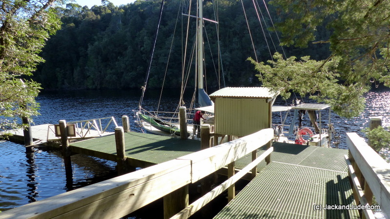
By mid morning April Fools Day, Banyandah once again lay serenely alongside Sir John Falls dock with a brilliant blue sky overhead, and us, in full wilderness garb, very much alone in one of the world’s most scenic wild rivers. The shallow rain event due a bit later sent us quickly climbing the steep Goulds Landing track to the start of the old shoe road with both of us chuckling. The transformation from walking paved streets and hearing noisy machines improving the road to the new fish depot, to weaving and bobbing under tree limbs through a rugged forest had taken just one short day and night.
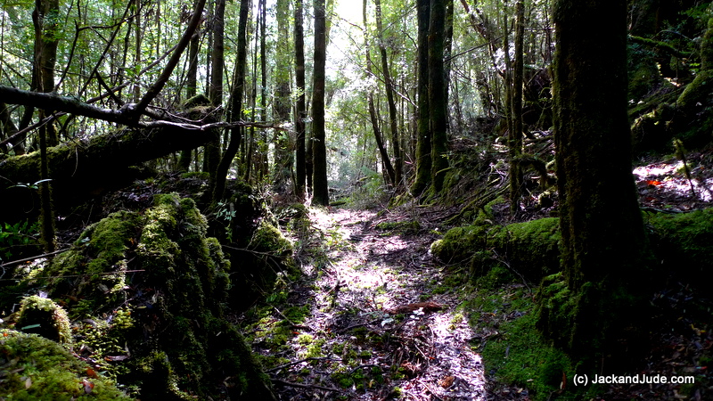
The first part of the track now visually clear was a delight to walk upon while imagining the horses hauling chaff along it. The going was easy like a walk in the park with compressed vegetation underfoot, carpeted by brown myrtle leaf litter. About two hundred metres along we began noticing that the tree fall across the track had been broken off, small branches snapped by people pushing through. Straight to mind popped the Launceston schoolchildren who we had met two weeks earlier ferrying themselves across Cataract Creek to gain access to the Goulds Landing homestead. Seeing the start of the shoe road quite visible, they probably could not have resisted rushing curiously ahead, ten of them clearing the way for others. What a natural playground. A living classroom surrounded by magical sights. They would have seen trees cohabitating, living together in a riotous mess; one falls down and, oh well, the others simply grow around it and continue on living. No complaining, just getting on with life, a tolerance between them. Wouldn’t it be wonderful if man could live like that?

Myrtle Leaves (Nothofagus cunninghamii)
Knowing we’d be walking this route several times, as we went along we snapped off dead limbs lying across the track and shoved rotten trunks aside to make the route safer for us, and for those that might want to take the journey into this fabulous rainforest. As we did, the jumbled mess became a sublime platter of Nature. Close around us was such a wonderful mass of trees and scrubs. Amongst them Sassafras, their gloriously shiny lance-shaped leaves, which have a saw tooth edge, adorn trees that can grow to 45 metres tall and 150–200 years old. Its light grey to brown bark contains tannin and essential oils that smells strongly of cinnamon. Some think the piners harvested every Huon Pine, the prince of Tasmanian timbers, but everywhere along the track there were Huon Pines from tiny tots a decade old to ones growing for centuries. Averaging just a millimetre growth in girth a year, their drooping light green foliage made up of tiny scale-like leaves spirally arranged on twigs are easily spotted. Myrtles, the predominant specie in Tasmania’s cool temperate rainforests, were seen wherever we looked. In fact their leaves carpeted the forest floor in an amazing collage of red through to yellow. On Myrtles, new spring growth is red to bronze which develops into a glossy green leaf that becomes thick and stiff as they age, producing a dark green shade. Their millions of small leaves grow to about the size of triangular shaped confetti with a coarse tooth edge.

Sassafras and Huon Pine amongst our Nature’s treasures
Within half an hour, we were up to what we had dubbed ‘three ways,’ where three vague tracks lead away in different directions. It was at that point the first time that we’d come unstuck by taking the central track, so this time we spent time investigating the left track looking for telltale signs to confirm that we had indeed returned on that track.
Back again the next day we followed the left hand shoe road and re-found the hydro sign then continued on, breaking through or climbing round tree falls, clearing dead vegetation aside and marking with pink tape as we went. Slow going, we only managed to add another 500 m before being stopped by a huge Huon Pine fallen across the track. This became day two’s turn around point. When checking its GPS position, that night we were still well short of the furthest point we’d been previously.
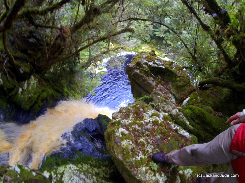
It shook so much, he feared it would fall into the pool far below.
After two days of clearing and marking, a welcome drop of rain kept us in bed cuddled up and purring. When the mist lifted, a leisurely climb to the top of Sir John Falls over the recently cleared track put Jack in Sir John’s seat at the edge of the drop off with bright amber water flowing over beautiful mossy rocks. But it shook. So much he feared it would fall into the pool far below.
Easter Saturday was another fine weather day and we were off the boat early, keen to make an intensive effort to reach the button grass plains and find the elusive bridge. In the lead, this bush bashing is hard on Jack’s shins, which after our earlier life exploring coral reefs, have little enough flesh. When it comes to looking after himself, he’s a bit dim witted, opting to just get on with it. But he must be getting a bit tired of bleeding shins because in a brain wave he made shin guards from camping mat foam held in place by soccer socks.
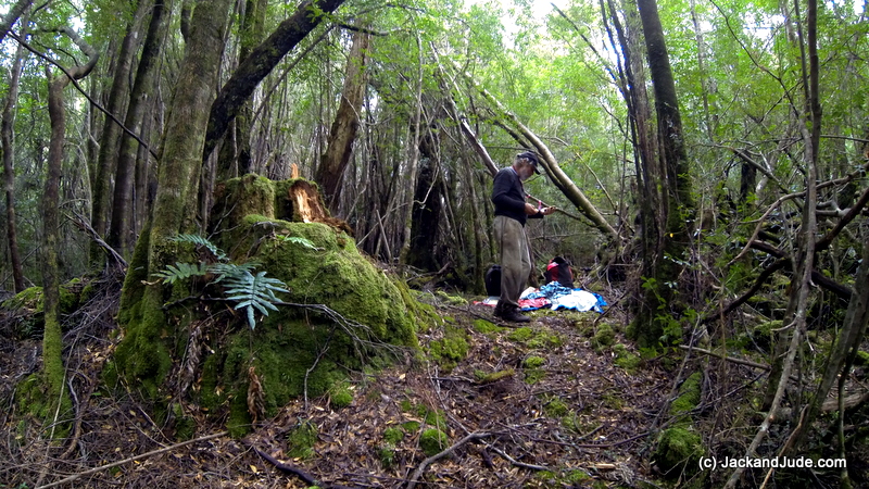 In one hour, we were at the fallen Huon Pine and pushing around it. Then sighting the shoe-road at intervals, we forced our way around obstacles leaving pink tape as we went. With so much vegetation in our way, it was essential we left strategic markers so we could safely find our way home. Often Jack and I called to the other, the vegetation so thick we couldn’t see more than a few metres and our voices so muffled by the still forest that we found it best to use the bushman’s code, a simple ‘Cooee’ letting the other know we were okay. Relaying information often got confused until we came together. Ploughing ahead, Jack used a compass to not get turned around.
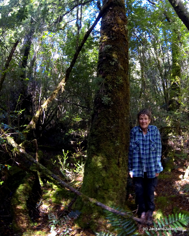
One of the grandest living Huon Pines we’ve ever seen
A tiny patch of glorious sunshine shining onto one of the grandest living Huon Pines we’ve ever seen called for an early lunch in a dry streambed. Then Jack climbed a nearby rise to see if he could sight the King Billy Range while marvellous thoughts filled my head. Had this pine been left for a rainy day? Or had it been too small to harvest?
After another hour of pushing through we were foiled again, but not before finding another hydro sign and two pieces of old red tape marking a route someone else had taken, plus a small trickle of flowing water, our first stream. Checking our map, medium forest with low dense vegetation lay a few hundred metres ahead. Would that be easier or more difficult to penetrate? Saturated with sweat, aching in legs and arms, with our bed at least two hours through darkening surrounds, we saw that our elusive bridge was still 1.5 km further on. So we tied one last tape and turned around. A wise decision. With some difficulty, we retraced our route through jungle, losing our way several frustrating times.
Three hours later, back on board at six-thirty with a mere hour of daylight up our sleeve, when plotting our last position we found that we were now 80 m further on from our furthest penetration, and more east. In discussing the possibility of yet another attempt, the long travelling time out and back would leave little time for further exploration, especially when the days are getting shorter. What was needed would be to take our camp with us and work from there. We’d found water so that wouldn’t be a problem. But before that, we needed time off.

Darkness falling, a rain shower threatens
Our previous exploration of this area –
Search for Piners’ Shoe Road


