

When HMS Investigator reached New Holland (WA) in December 1801, Captain Flinders with his complement of 88 followed orders and sailed eastward around Cape Leewin and encountered strange sights in a place then called Peter Nuyts Land. They interacted with Aboriginal people, replenished supplies, explored, and charted everything along the way. Exploring a strange land, they made many new discoveries, including the cliffs of the Nullabor Plain and the wild coastline of the Eyre Peninsula, before reaching the Spencer Gulf.
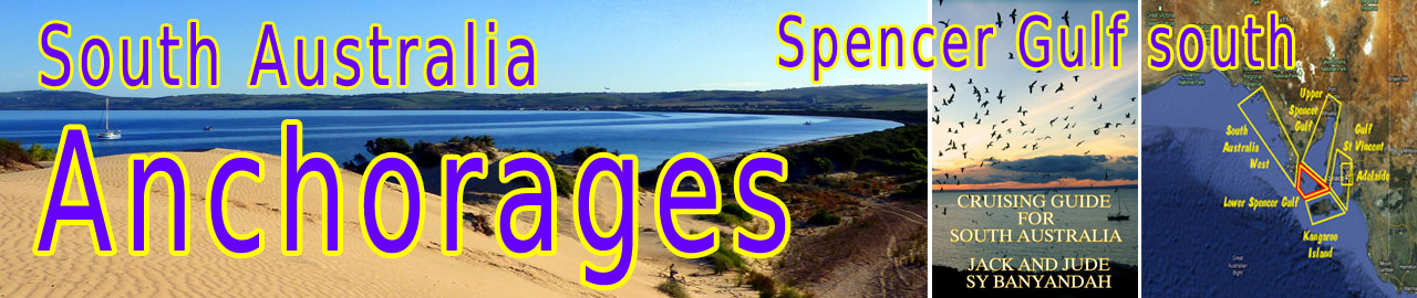
Spencer Gulf is the westernmost of two large inlets on Australia’s south coast facing the Great Southern Ocean. Spencer Gulf is 322 km (200 mi) long and 129 km (80 mi) wide at its mouth. The western shore is the Eyre Peninsula, while the eastern side is the Yorke Peninsula, which separates it from the smaller Gulf St Vincent. The largest towns on the gulf are Whyalla, Port Pirie, and Port Augusta. Among smaller towns are Port Lincoln and Wallaroo.
In April 1802, Matthew Flinders was the first to document these two incredible gulfs:
‘Our examination of the Gulf of St Vincent was now finished; and the country round it had appeared to be generally superior to that on the borders of Spencer’s Gulf.
Yorke’s Peninsula between them is singular in its form, bearing some resemblance to a very ill-shaped leg and foot. ‘
IMPORTANT NOTE ON CHARTS AUS 345 and 780 (from Hydrographic Office)
Caution is required as positions taken from the chart and entered as waypoints may be up to 1/2 nm in error.
Regard all GPS locations as approximate, even though our positions were taken from a modern chartplotter.
Anchorages along that ill-shaped foot
Excellent in calms & northerlies, minimal protection otherwise.
We have made this passage many times and usually do not linger because of conditions. A long swell from deep southern ocean can develop and needs to be considered when close to shore.

Point Devonport anchorage
Point Devonport
35°09.35’S~ 137°20.91’E
There is plenty of sand on the point protecting the anchorage from west. Look for bare patches in the thick ribbon weed in depth 6 m. Plenty of squid. One house in sight – often deserted.
Marion Bay
35°14.31’S ~ 136°59.42’E
This is from a knowledgeable friend who needs 1.5 m to float, Master John anchors either side of the jetty.

Stenhouse Bay
Stenhouse Bay
35°16.61’S ~ 136°56.91’E
Gateway to Innes National Park, just over 300 km by road from Adelaide, the anchorage is actually inside the National Park. From the campground at Stenhouse Bay, where there is a toilet but little else, it is a hop, skip, and a jump to the general store and tavern.
Anchorage:
The anchorage mentioned above can sometimes be too active for Banyandah. We have moved closer in and found rock bottom at 35°16.67’S ~ 136°56.91E’ depth 8.5m. Chain noise! Short snubbed!
John and Inara of Desiree, 1.5 m draught, anchor even closer in at: 35°16.56’S ~ 136°56.88’E
The town of Cape Spencer that stood nearby circa 1927, had a population of 150, the gypsum company employed 80 men. Electric lights in all buildings, a public hall, school, post office, general store, cricket oval, chemist, butcher and baker and this lead to a successful request to change the town’s name to Inneston, to honour its founder, W.R.D. Innes.
The gypsum was shipped through Stenhouse Bay, transported there on a wooden rail tramway, and then stockpiled at the top of the cliff before ore trucks on rails and cables transported the gypsum down the steep face to the 164 metres long jetty at Stenhouse Bay.
The Waratah Gypsum Company supplied most of Australia’s needs until it closed its works in 1972. The town was then sold to the South Australian Government, which demolished it! – Except for the few houses required for the rangers who administer Innes National Park.

Cable Hut Bay Anchorage
Cable Hut Bay
35°17.50’S ~ 136°53.98’E
Shelter from NW to N
The W half of the bay seems rocky while there are sandy spots in the E half. The bay is shallow for quite a ways offshore. Holding seems good in sand with light weed patches.
Straightforward entry, but the charted shoals can rise suddenly, creating breaking waves, dangerous in storm conditions. There is road access along the hills above the bay and a wooden walkway to a lookout at the Eastern end of the bay.
Strong N to NW winds can be followed by a SW change, when you might move as we did once to weather a storm at Althorpe Island.
Althorpe Island
35°22.12’S ~ 136°51.92’E
Shelter from SW through W to NW
Seeking shelter from a westerly gale, we anchored in the small bay on the NE side of the island, north of the jetty, with good holding in 6 to 8 m over sand. The exposed reef extending to the north by 500 m gave good protection from the huge swells rolling into Investigator Strait.

Althorpe Island lighthouse stands atop 90 metre cliffs, with the only access from a small beach on the north side. Here in 1877, a small jetty was built for landing supplies. From this jetty, which is 3 m wide and 45 m long, the cliff was scaled using a ladder. Up this, all supplies including building materials had to be hauled! Later on, a small tramline and flying fox were erected to ease the arduous job. Later still, a steam engine further ease the task of shifting supplies. The jetty is now in a dangerous condition, and does not have ladders for access.

Althorpe Island from Cape Spencer
Once the jetty and cliff access were finished, the main task of building the lighthouse could commence. The tower was built from limestone and sandstone quarried on the island. Chance Brothers supplied the glass gallery, lantern, and dome. And on 14 February 1879 the Althorpe Island lighthouse was illuminated for the first time.

The Jetty and Flying Fox

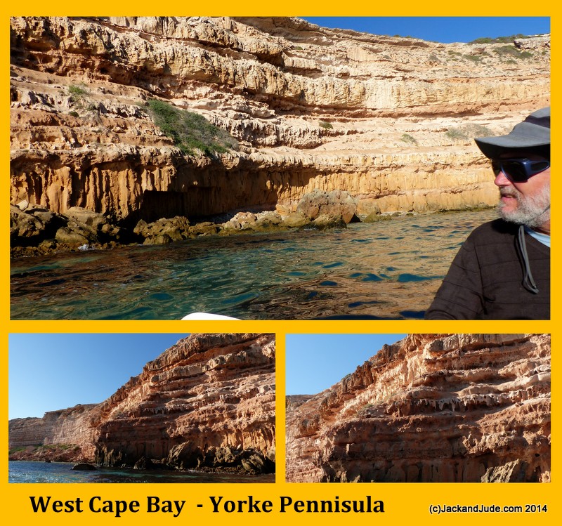
West Cape Bay Anchorage
West Cape
35°14.61’S ~ 136°49.77’E
Shelter from NE to S to SW
We had read that West Cape had better holding and a less dangerous entry than Pondalowie a little further north. That appealed when seeking shelter from a SW storm and we attempted entry and got as far as nearly releasing our anchor when two combers stood up and stretched across the bay. As they ran along the rock wall next to us they peaked and we had seconds to come heads up before they broke over us. After that fright, we hi-tailed it out of there using lots of throttle.
Anchorage: Enter keeping close to southern shore, follow the break into the lee of the cape. Be careful of the reefs to the north of the bay. The recommended anchorage is close in to cliffs, just off a distinctive rock formation. Some swell may lick around the tip of the cape but the holding is good and the anchorage generally comfortable. It is a dangerous winter anchorage, but in the summer its uninhabited sandy shores and marvellous cliffs make it a perfect stopover to and from Port Lincoln. The high cliffs provide excellent shelter from southerly weather, a great place to snorkel or kayak, and good fishing. It is said this bay provides better holding than Pondalowie.
Pondalowie
35°13.93’S ~ 136°50.29’E
Shelter from all directions
The bay is attractive with a few shacks and moorings, but the approach must be made carefully. The anchorage is in the southern part of the bay. The holding is not good with only a thin layer of sand over rock base. It may be possible to pick up a mooring. A shift in the wind to the NW will mean anchoring in the lee of the south island. But again watch out for moorings.
Note: It is essential to identify the three islands at the entrance to the bay. The South Island has a light on it and it is to the north of this island that the approach must be made. There is a submerged rock approx 500 meters NE of the South Island.
Island anchorages to Cape Catastrophe

Wedge Island
Main Bay,
35°09.00’S ~ 136°28.72’E
Shelter from S to SW
Anchor south of the main house and jetty. If conditions allow, you can anchor in 6 M very close to shore in sand patches.
Once on Banyandah, although we had 6 m SW swells outside, we found good shelter in 13 m ribbon grass/sand bottom with light boat motion. When the wind changed to NE12 at midnight, we sailed for Port Lincoln overnight.
Attractive anchorage, a few houses visible, good fishing, heaps of squid, walks on shore, can be uncomfortable if swell comes from SE, in which case, move to West Bay. If the wind shifts to N or NE, anchor in the lee of North Islet if conditions allow.

Wedge Island
West Bay,
35°08.80’S ~ 136°26.80’E
Shelter from NE through E to S
West Bay anchorage is in about 10 m depth on the western side of Wedge Island and frequented by cray boats. When approaching from the north, be aware of West Rock. There is a deep passage about 500 m wide between the NW corner of the island and West Rock.

Thistle Island
Whalers’ Bay,
35°00.33’S ~ 136°10.97’E
Shelter from Winds SE through S to W
Holding is good in sandy patches.
This is a beautiful spot but can be uncomfortable if the swell licks around the point and the wind holds the bow to the shore. In which case consider moving to Snug Cove.
 Banyandah has anchored here several times. We have walked a lot of the southern end of the island, very interesting, and caught big feeds of King George whiting in the sand surrounded by weed. Yummy.


Thistle Island
Snug Cove,
34°56.32’S ~ 136°05.63’E
Shelter from winds NE through E to S
North western corner of island, sheltered by a north westerly projection of land at the southern end of a mile long beach that starts at Observatory Point.
Shallow weedy bottom; hence the actual anchorage is outside the Cove with the cliffs in line to the SW. The bottom seems to make for good holding.
Note: Flinders anchored here when sending his red cutter on the disastrous journey to seek a water source on the mainland. This resulted in the loss of all hands. He named the features in Thorny Passage after the victims or the event.
In W or NW weather, Memory Cove or possibly Shag Cove on the mainland to the W offers better protection. The nearest protection from strong N winds is probably under Maclaren Point.
Thistle Island
Mittler’s Cove,
34°57.40’S ~ 136°05’E
Shelter from N through NE to E
Situated at the western end of Thistle Island, between Nose Point to the north, and Carrington Point to the south. The eastern end of Hopkins Island is about 1.5 km to the west. A reef, not clearly shown on some charts, runs underwater from Nose Point to at least half way to Hopkins Island. If approaching from the north, keep to within a few hundred metres of Hopkins Island.
Anchorages on Eyre Peninsula

Memory Cove
34°57.63’S ~ 135° 59.46’E
Shelter from SE through S to NW
It is quite deep relatively close to shore, but there are some moorings for public use. Memory Cove was named by Captain Matthew Flinders in memory of the sailors drowned in Thorny Passage in 1802.
Captain’s logbook , Wednesday 24 February,
“… I caused a stout post to be erected in the Cove, and to it was nailed a sheet of copper upon which was engraven the following inscription….”
Memory Cove is an attractive sandy, tree lined cove on the Jessieu Peninsula close to Port Lincoln. Quite popular due to its shelter and beauty and can be a little crowded. A delightful walking trail south of the beach reaps good views of Thistle Island.

Shag Cove
34°54.41’S ~ 135°58.78’E
Good shelter from westerly weather. A small cove about 3 mi north of Memory Cove on the Jessieu Peninsula. Less known and more peaceful at busy times of the year. Fairly good holding in weedy bottom.


Port Lincoln
Marina Entrance, 34°44.50’S ~ 135°52.70’E – Shelter from All Directions.
Town Beach, 34°43.16’S ~ 135°51.73’E – Shelter from NE through S to NW in 5 m. sand and weed, good holding.
Before the marina, yachts used to anchor in front of the town or tie up to the jetty there. Today, some say the marina, located a little south of town, represents the best option for visiting yachts. If you like the freedom to move around, maybe pop into the yacht club for a beer, or into town for a meal, there are several good spots right off the beach that is just across the channel from Boston Island, and two hours across calm water to the Lincoln National Park.
If taking the marina option, tie up along the long pontoon in the channel just before the pub. Then contact the marina management on (08) 868 33399. Or Malcolm Blake, marina manager, MOB 0427 059 040. VMR Port Lincoln is also contactable on VHF ch 81 for local information and help.

Facilities: This major city on the Eyre Peninsula has every facility for visiting yachts. It is a major fishing port and a regional centre providing the infrastructure for the West of South Australia. The airport has numerous daily flights to Adelaide as well as connections by bus. There are ship chandlers, slipways, accommodation, hospitals, in fact every amenity a visiting yacht could need including the wonderful Alex Stenross maritime museum. A must see.
Opening times:
Tuesday, Thursday and Sunday 9.30am. – 4.30pm.
Saturday and Public Holidays 1.00pm to 4.30pm
Closed Xmas Day

We put on a free film night at the Axel Stenross Museum A Fine Community Spirit
As a base for cruising, Port Lincoln is one of the best in South Australia. The islands and coves around Pt Lincoln represent some of the most varied and interesting cruising grounds in the state.
The modern marina is a little to the south of town, in an area which incorporates one of the largest fishing fleets in the southern hemisphere. There are various marine supply and repair businesses associated with the fishing fleet there, as well as a good pub, restaurant and accommodation in units at the marina. Taxis are available to take you to town, which is about 10 minutes away by car. If you have a lot of things to do, maybe hiring a car would be more convenient.
Fuel is available at a very busy berth built for big fishing boats, it takes only credit cards. This berth is especially busy early mornings, but after the rush, a gap can be found, park north end. If jerry cans are an option, near the marina is a service station, incorporating a small shop. Hot showers can be had at the Community Recreation Centre which is located at the marina and includes a large indoor swimming pool, sauna and gym facilities.
Next >> Gulf St Vincent North – the Joesph Banks Group to Port Augusta